Zhenjiao Jiang, Dirk Mallants, Lei Gao, Tim Munday, Gregoire Mariethoz, and Luk Peeters
Geosci. Model Dev., 14, 3421–3435, https://doi.org/10.5194/gmd-14-3421-2021,https://doi.org/10.5194/gmd-14-3421-2021, 2021
Short summary
Short summary
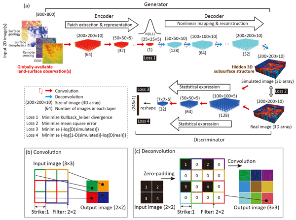
Fast and reliable tools are required to extract hidden information from big geophysical and remote sensing data. A deep-learning model in 3D image construction from 2D image(s) is here developed for paleovalley mapping from globally available digital elevation data. The outstanding performance for 3D subsurface imaging gives confidence that this generic novel tool will make better use of existing geophysical and remote sensing data for improved management of limited earth resources.
Zhenjiao Jiang, Dirk Mallants, Lei Gao, Tim Munday, Gregoire Mariethoz, and Luk Peeters
Geosci. Model Dev., 14, 3421–3435, https://doi.org/10.5194/gmd-14-3421-2021,https://doi.org/10.5194/gmd-14-3421-2021, 2021
Short summary
Short summary
Fast and reliable tools are required to extract hidden information from big geophysical and remote sensing data. A deep-learning model in 3D image construction from 2D image(s) is here developed for paleovalley mapping from globally available digital elevation data. The outstanding performance for 3D subsurface imaging gives confidence that this generic novel tool will make better use of existing geophysical and remote sensing data for improved management of limited earth resources.
In Australia, long-lived ILW from research reactors and radiopharmaceutical production represents the principal waste stream that requires deep geologic disposal. CSIRO and its partners aim to demonstrate the technical feasibility of the long-term safety of borehole disposal in deep geological formations. We will highlight the main findings from the RD&D undertaken so far.
In Australia, long-lived ILW from research reactors and radiopharmaceutical production...